Very cool. Wish I had more aerial shots from when I was there to compare.
Of the 12 coaches, Rush picked the one whose fans have the deepest passion, the longest memories, the greatest lung capacity and … did I mention deep passion?
Chicat wrote:Very cool. Wish I had more aerial shots from when I was there to compare.
Even from 10 years ago campus is way different. There's soon to be 9 5-15 floor high rise apartments on the northwest part of campus between Euclid, Park, Speedway and 2nd St. Since I started there 16 years ago there's been like 4 new dorms and several new hospital buildings and like 4 new class buildings and two parking garages built. If you haven't been back since before 2002 or so then the campus is halfway to unrecognizable
Last edited by ASUHATER! on Mon Aug 24, 2020 4:09 pm, edited 1 time in total.
i was going to put the ua/asu records here...but i forgot what they were.
Wow that is crazy. I graduated in 99 and haven't been back to Tucson in about 6 years. Seeing those pictures brings back memories of what used to be there. Carls Jr, Jack in the Box, Subway. Losbetos, etc.
My 4 years at U of A were the best time of my life even though I was broke.
Last edited by OriginalAZ on Tue Aug 25, 2020 6:48 am, edited 1 time in total.
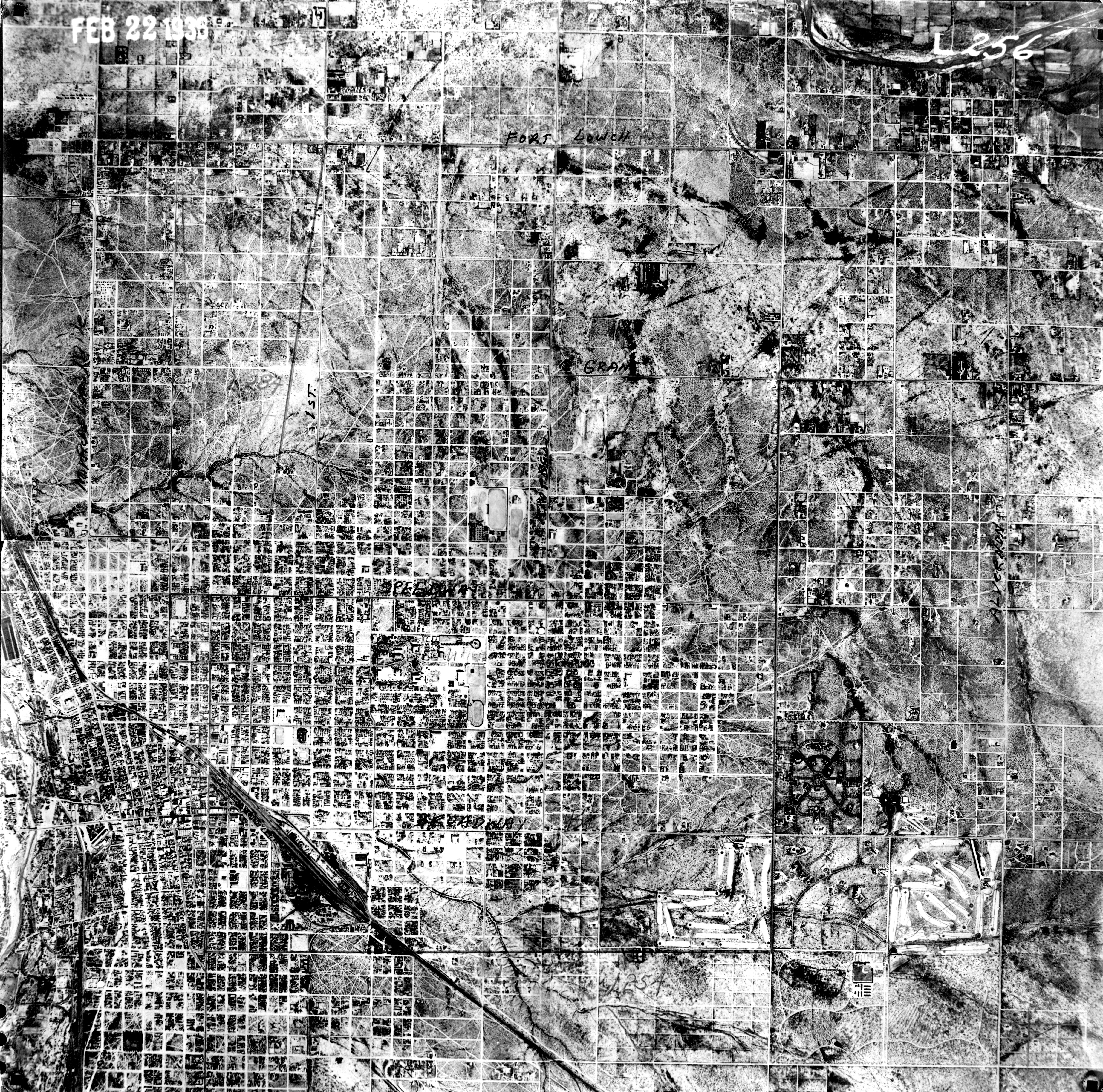
This image covers about Tucson Blvd on the west, speedway on the south and swan on the east. Pima county had hundreds of images of this 1936 survey for access.
That stretch of Tyndall and Park is crazy. Could never have imagined it.
Marriott has to be livid they built before the city gave everyone (university) the right to go up into the sky!
Yea it's crazy. Like 3 of the apartments are only 4-5 floors but the two newest ones they're building are like 15. That whole corner of campus is a sea of high rises. Expensive too. Anyone who is anyone lives there now and they are the seat of Greek life and the height of cool. All the kids from Naperville and Laguna Beach and Bedminster live there. Living in an off campus house is for poor people.
i was going to put the ua/asu records here...but i forgot what they were.
scumdevils86 wrote:February 1936 aerial photography of Tucson. https://gis.pima.gov/data/layers/nrcsin ... s/L212.jpg" target="_blank
This image covers about Tucson Blvd on the west, speedway on the south and swan on the east. Pima county had hundreds of images of this 1936 survey for access.
That is awesome. That sharp bend in the wash on the left is Country Club and the wash splits on the right at Craycroft. Thats Tucson Country Club in between the split, looks like it was all farm land. You can even see River Rd above the wash is the same route it is today. Just below the bend on the left is Tucson Racquet Club and there appears to be 2 small bodies of water that are now gone.
Amazing how little the path of the wash has changed in 84 years.
1936:
2020:
Here is Ft Lowell and Craycroft:
You can see the outline of that neighborhood and I believe the darker spot above is what turned into the lake at Hill Farm:
Last edited by Jefe on Wed Aug 26, 2020 4:53 pm, edited 1 time in total.
Of the 12 coaches, Rush picked the one whose fans have the deepest passion, the longest memories, the greatest lung capacity and … did I mention deep passion?